About City Digital Twin Project
City Digital Twin Pilot Project aims to implement the digital twin as a technical solution that scales to real-world problems, including design, exploration and experimentation of urban environment and processes.


City Digital Twin Pilot Project aims to implement the digital twin as a technical solution that scales to real-world problems, including design, exploration and experimentation of urban environment and processes.

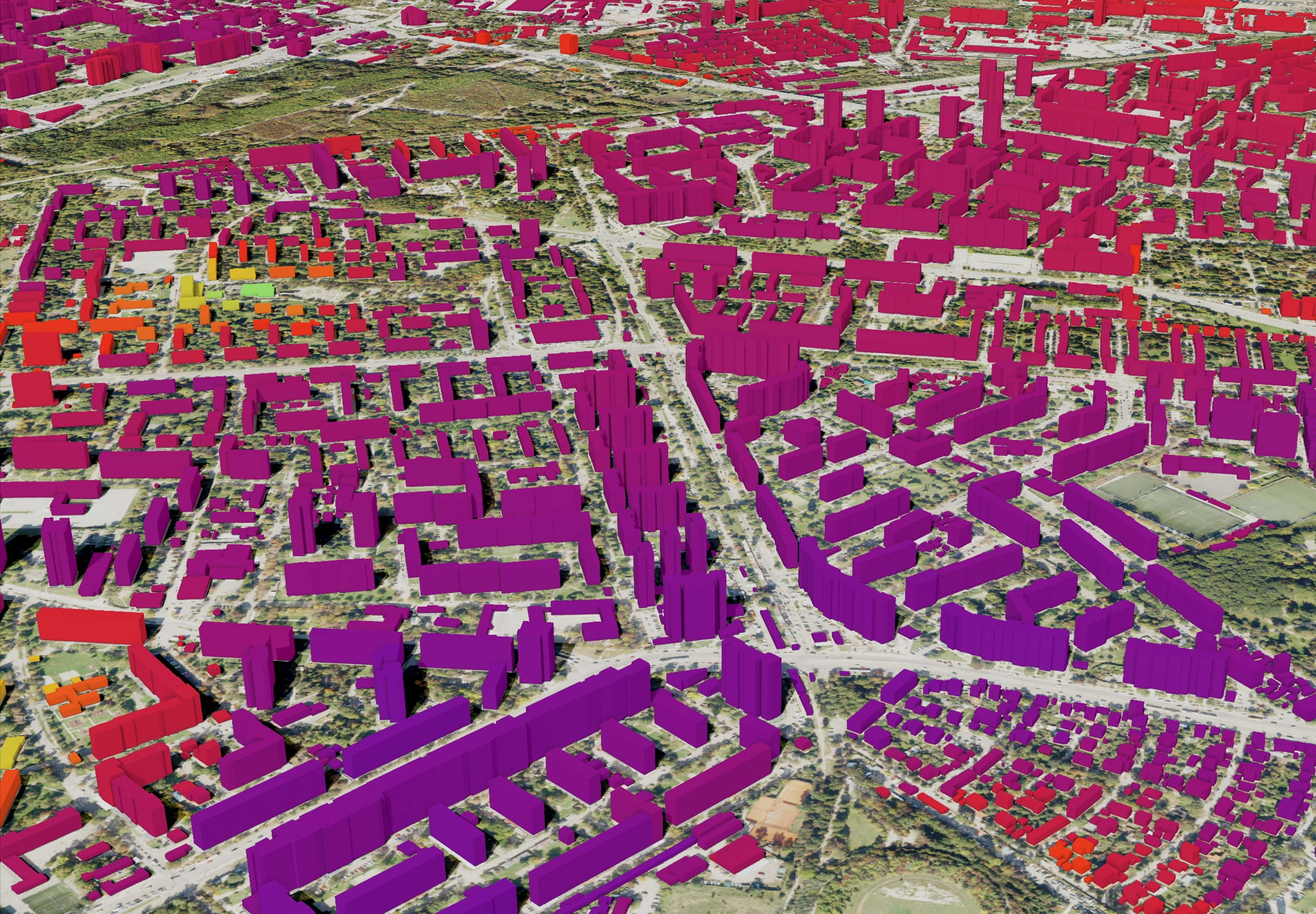
The 3D city model of District Lozenets and its visualisation are the first steps towards implementation of City Digital Twin pilot project of GATE Institute. It covers the Buildings and Relief thematic modules of CityGML 2.0. The 3D model of the buildings is hosted on the Cesium ion platform and visualized using CesiumJS.
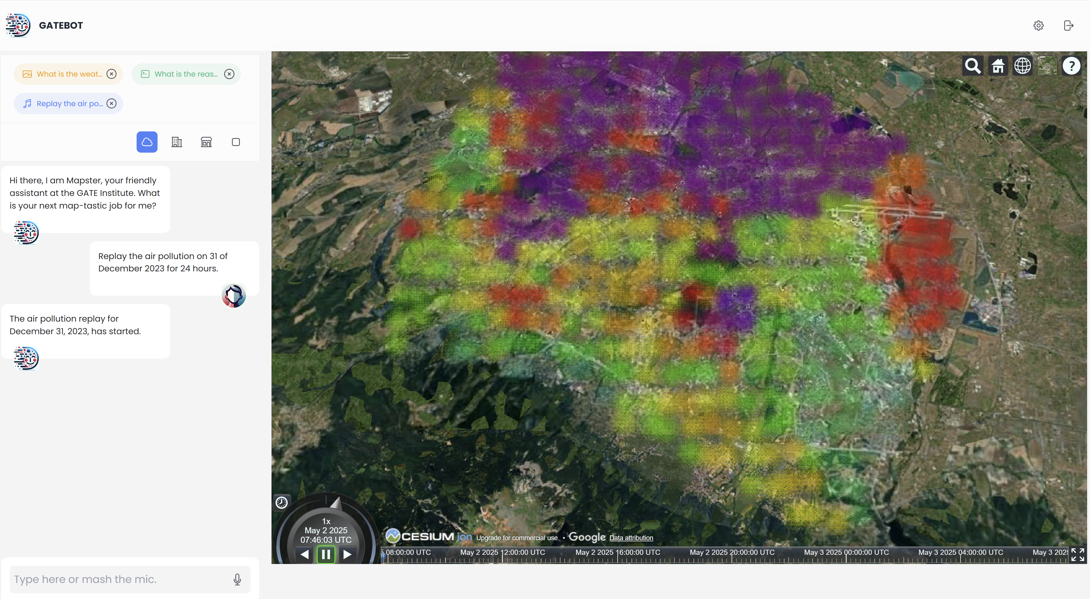
The study develops a cutting-edge Urban Digital Twin based on LLAMA 3.1 (70B), fine-tuned using the QLoRA method, and integrates air pollution data from Sensor.Community. The proposed system processes over 1 billion records of historical and current air quality data in the Sofia region, creating an interactive 3D city model.
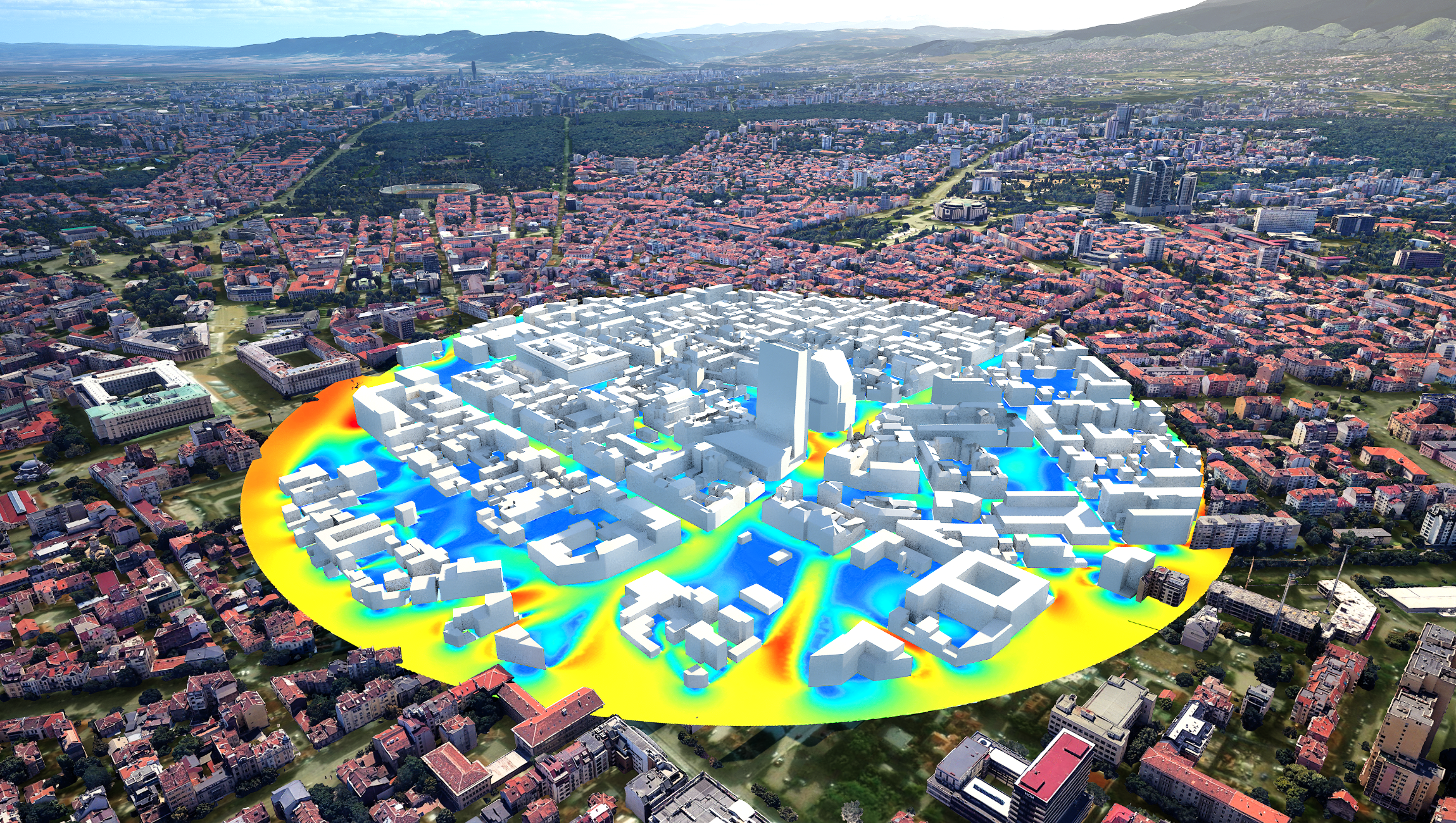
Computational Fluid Dynamics (CFD) simulations are now being widely used for the prediction and assessment of high-rise building aerodynamics and pedestrian wind comfort. Results from CFD wind simulation are reliable sources of quantitative and qualitative data useful to make important design decisions.

Indoor air quality and thermal comfort are two factors that affect occupant’s health, performance, and overall well-being. They are modelled, analyzed and predicted by applying CFD, so that suitable control measures can be taken in due time. The overall building design, ventilation and heating effectiveness is assessed and optimized through different what-if scenarios.
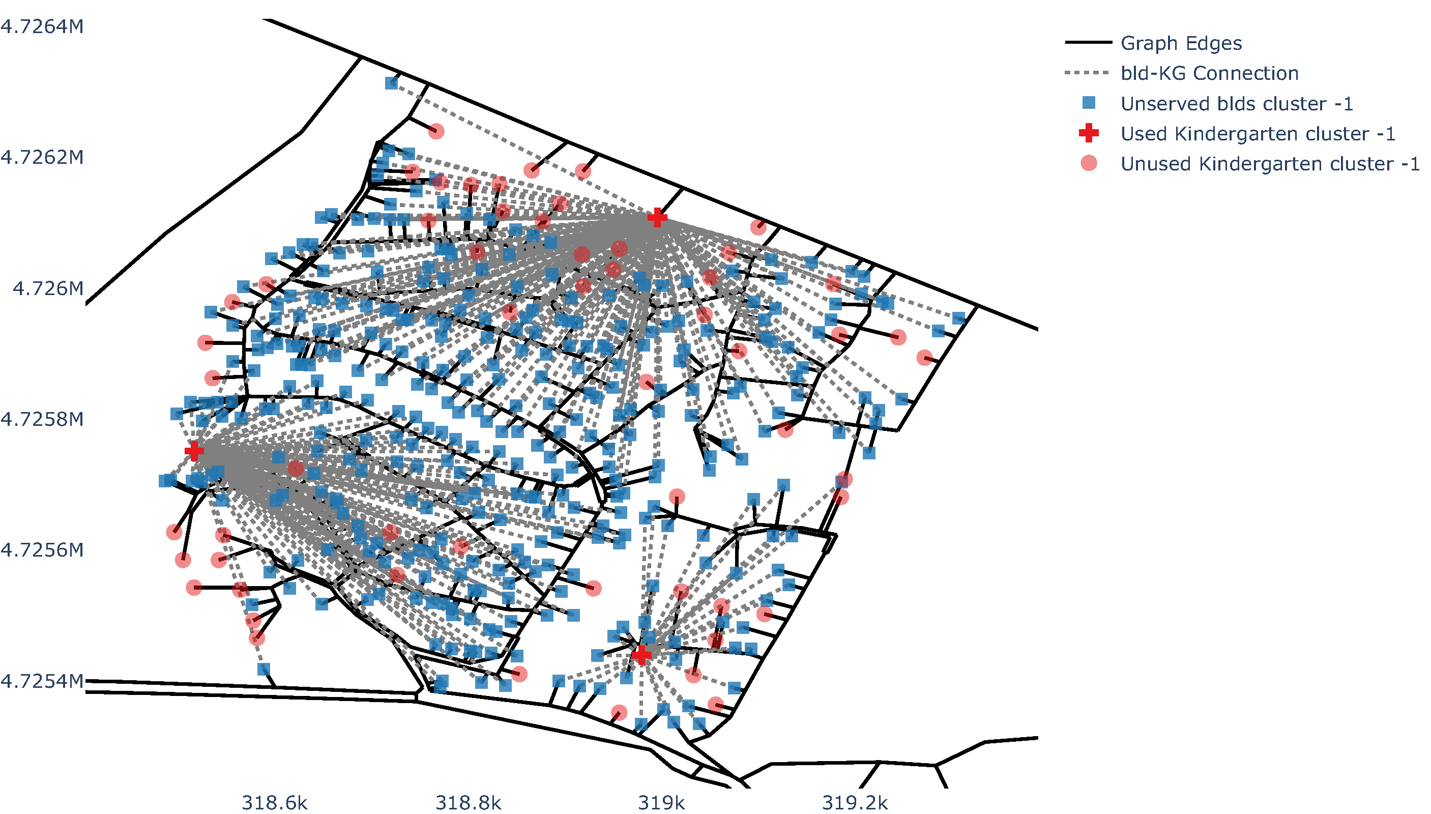
An automated approach for assessment of social facility coverage is developed. It solves a supply and demand problem based on a graph network, where kindergartens and nurseries are considered as supply nodes, and residential buildings as demand nodes. Supply and demand are balanced based on a 15-min walking distance and the capacity of social facilities.
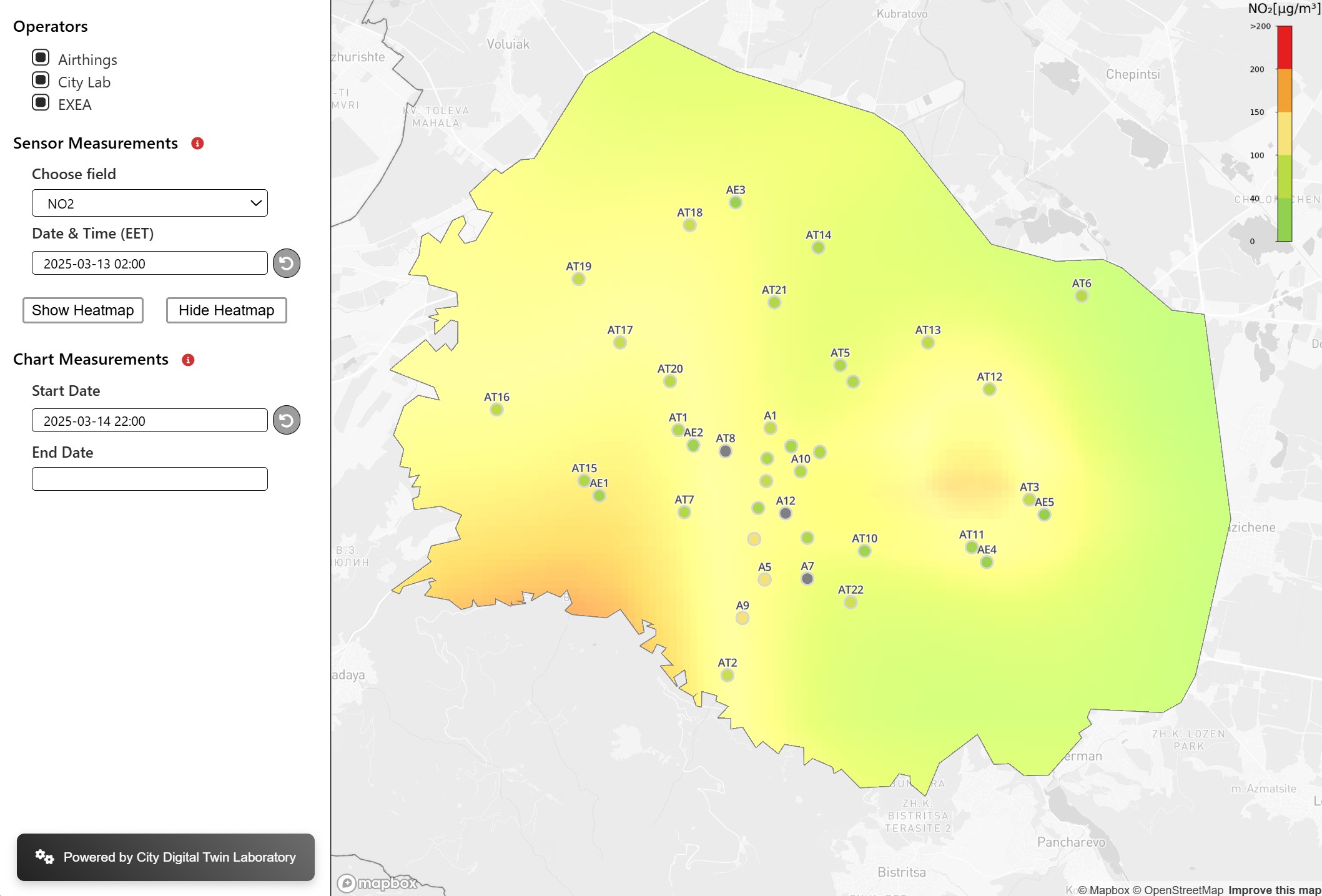
The aim is to provide a way of combining data from different sensor stations and to develop a platform for the real-time prediction of air quality throughout Sofia city. To achieve this, methods from the field of uncertainty quantification and statistical learning are used, which enable the analysis of existing sensor data in a probabilistic way.

Walking is the most accessible form of mobility, delivering benefits to both cities and their residents. To increase walkability, the pedestrian network, integrating all transportation modes, should be optimized. The pedestrian accessibility to public transport stops and parks in Sofia is evaluated by applying network and spatial analysis based on a 10-min walking distance.
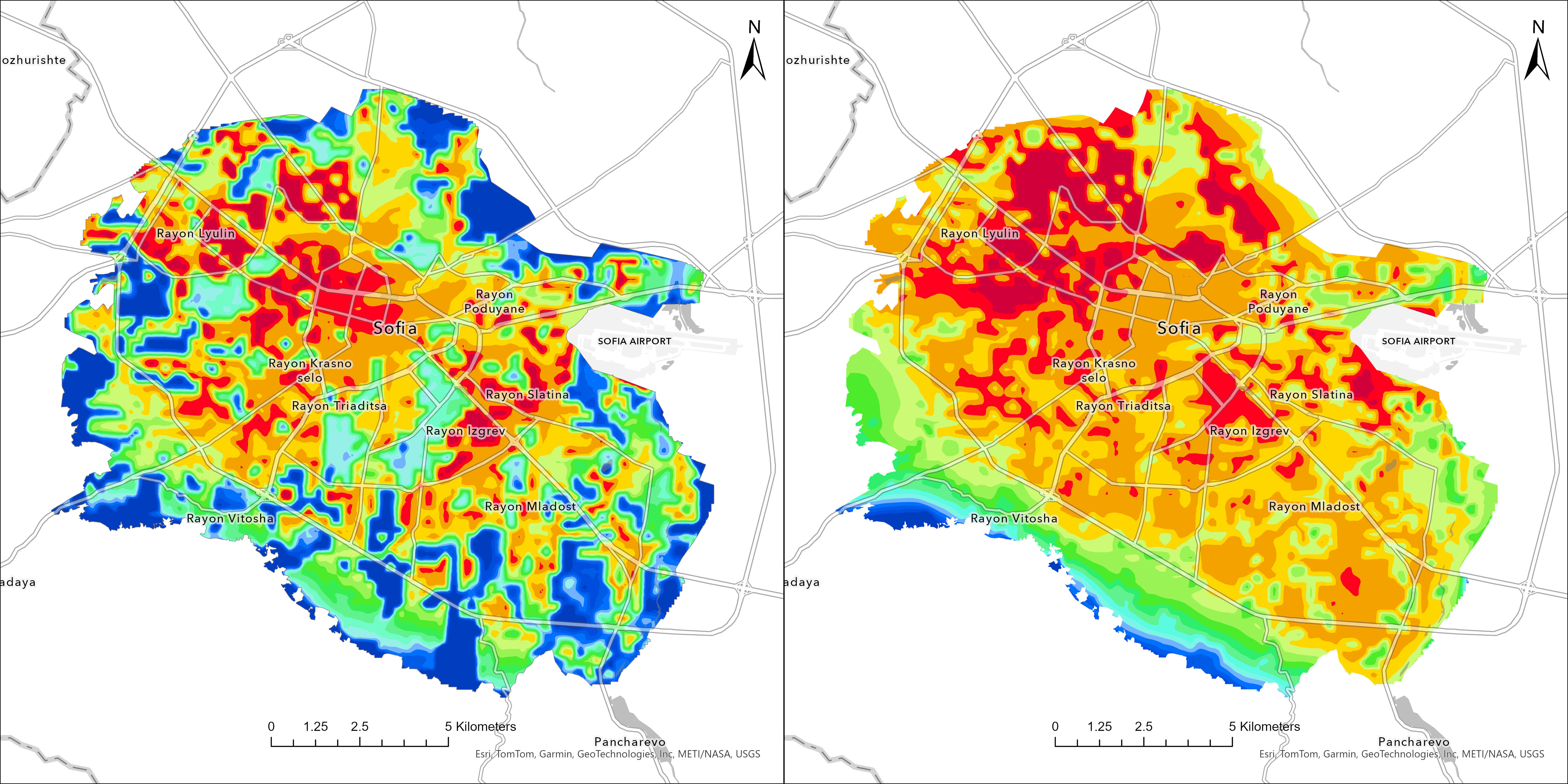
The study aims to numerically estimate the impact of UHI in Sofia and its surroundings on the air temperature using the state-of-the-art Weather Research and Forecasting (WRF) with very high resolution. The study also estimates the impact of building and transport separately ...
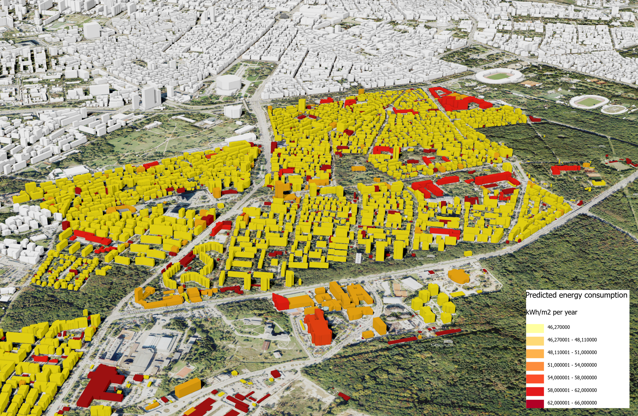
The study calculates the energy consumption of the residential buildings in Sofia based on the “Building certificates of energy characteristics” dataset, provided by the Agency for Sustainable Energy Development. For each building category, a distribution-free tolerance interval is computed ...
This study applies the 15-minute city concept and introduces an Accessibility Index that evaluates residential access to POIs, incorporating diversity metrics such as the Shannon and Simpson indices. These indices form a unique framework that not only evaluates walkability but also enables a more meaningful understanding of urban environments.
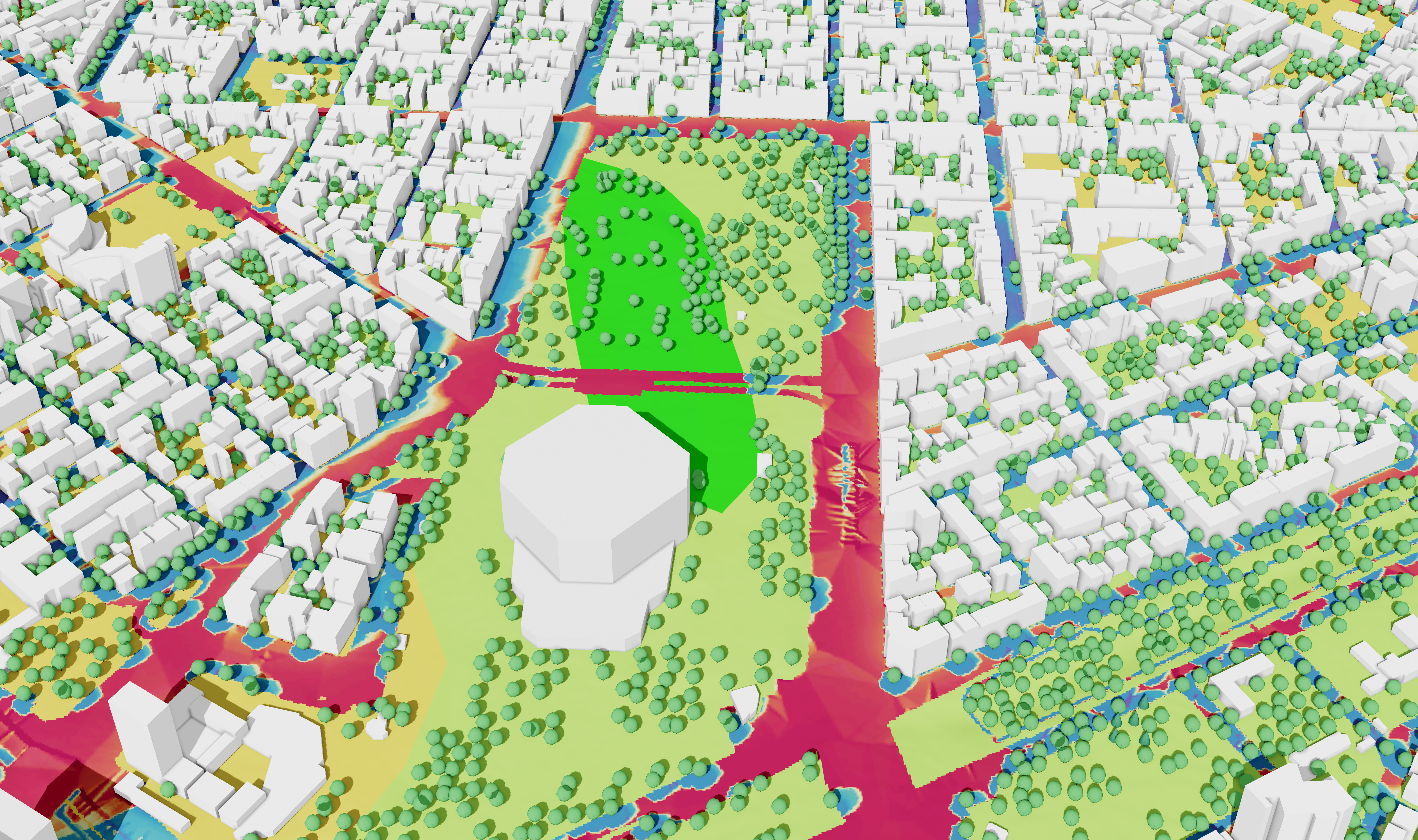
This study examines the calculation of solar incident radiation at the city scale in Sofia using remote sensing data for the large shading context in a mountainous region and 3D vector building data. The building footprints and the terrain are preprocessed using GIS. The solar calculation is con-ducted using a raytracing algorithm in 3D CAD at the city scale.
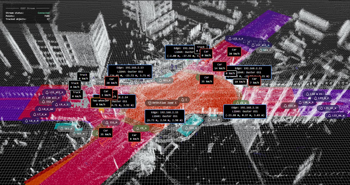
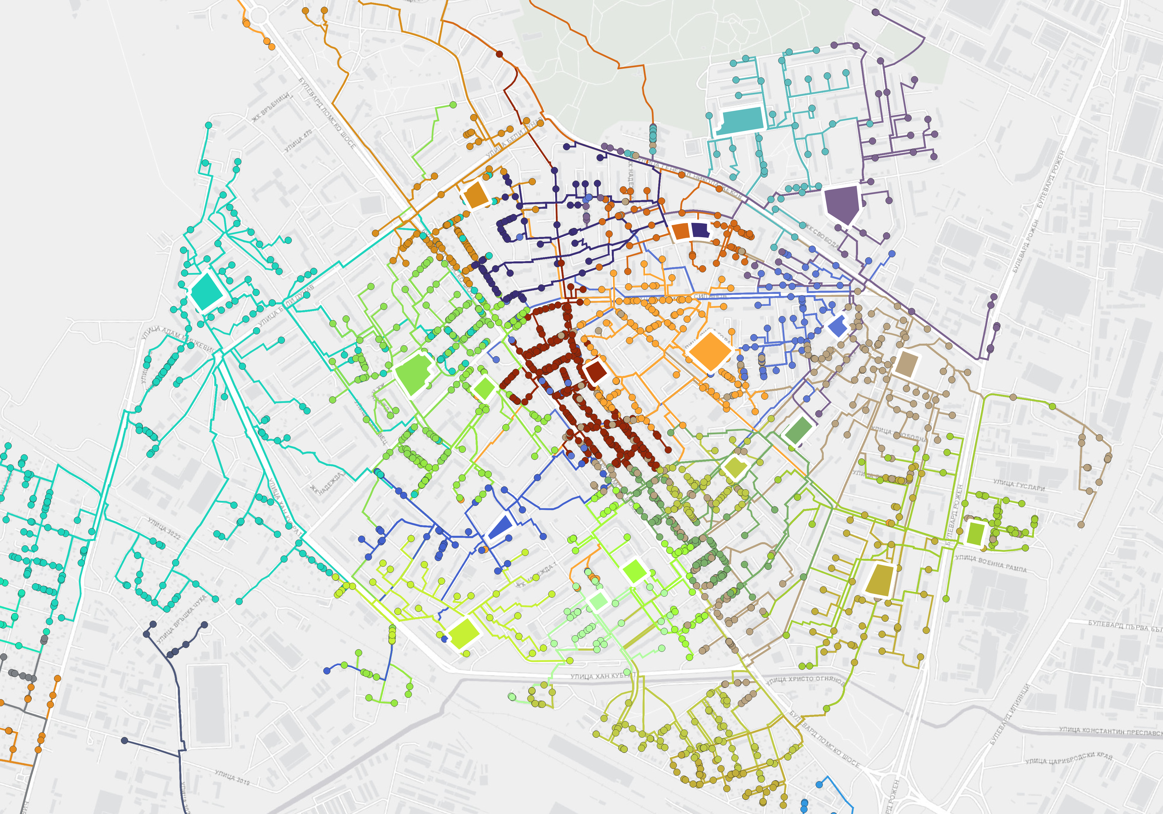
The study focuses on developing a novel digital-twin-based approach for micro-traffic simulation to support data-driven decision-making for increasing traffic safety through scenario planning. Leveraging the traffic data obtained through monitoring one of the busiest intersections in Sofia city, this research workflow shows the effective integration of LiDAR data and the urban digital twin concept in intelligent transportation systems (ITS).
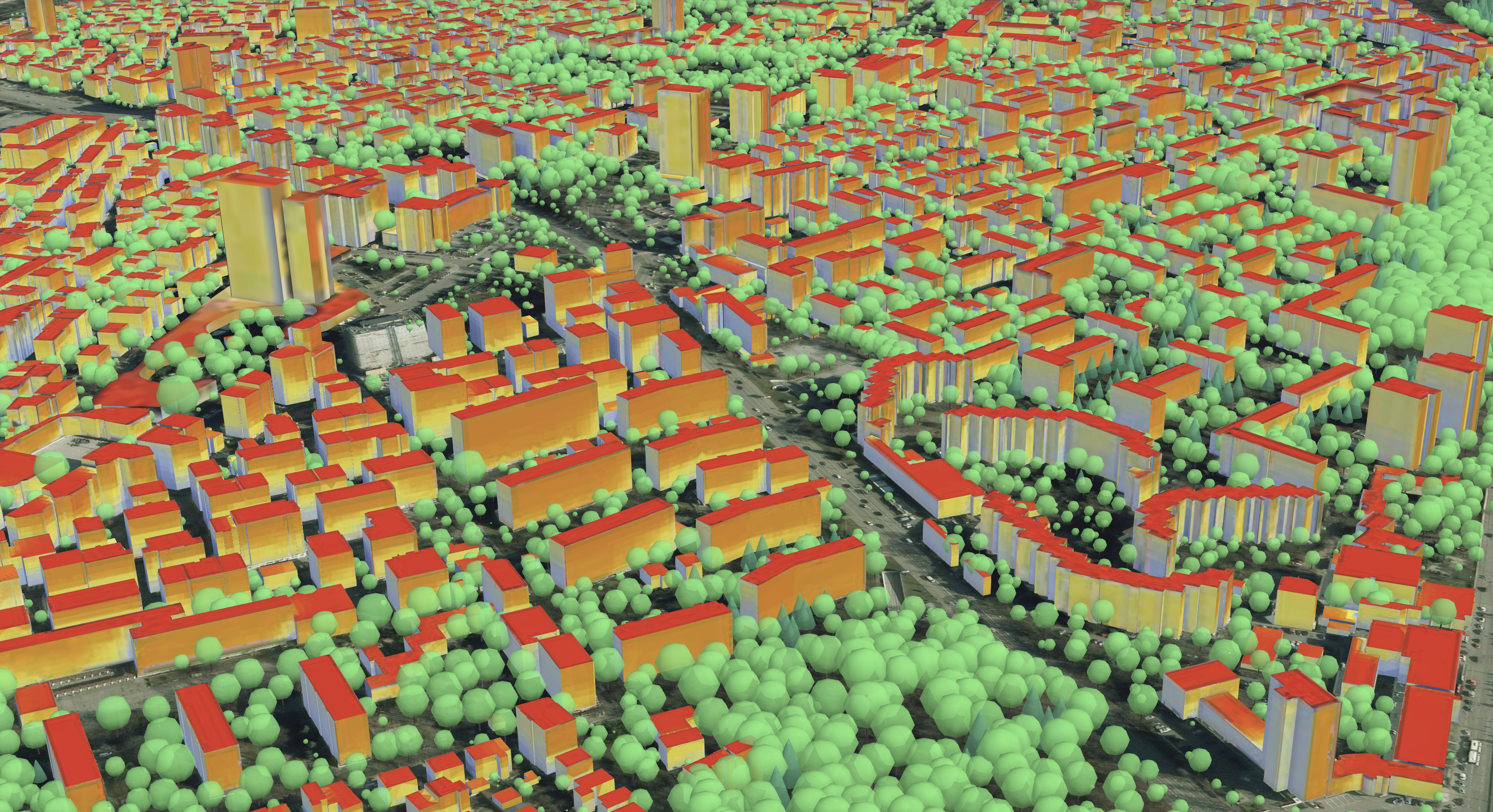
The study explores the heat index Wet Bulb Globe Temperature (WBGT) in the center and suburbs of Sofia. The results show that the incorporation of street trees provides shading, which substantially mitigates thermal discomfort by reducing direct solar radiation exposure and lowering surface temperatures.
The study aim to enhance Urban Digital Twins as dynamic decision-support tools for mitigating environmental impacts and promoting sustainable, green urban development. It proposes an advanced framework that integrates high-resolution climate simulations by the Weather Research and Forecasting model to evaluate and compare urban development scenarios.
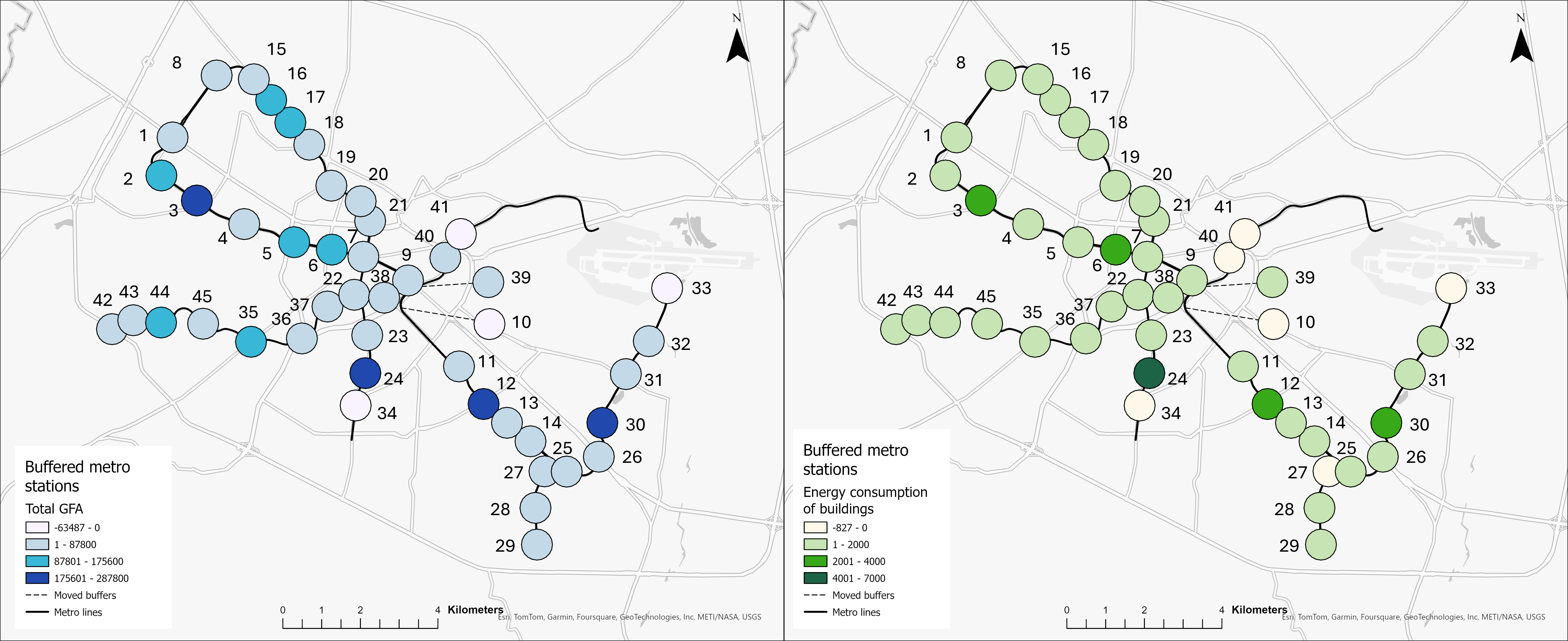
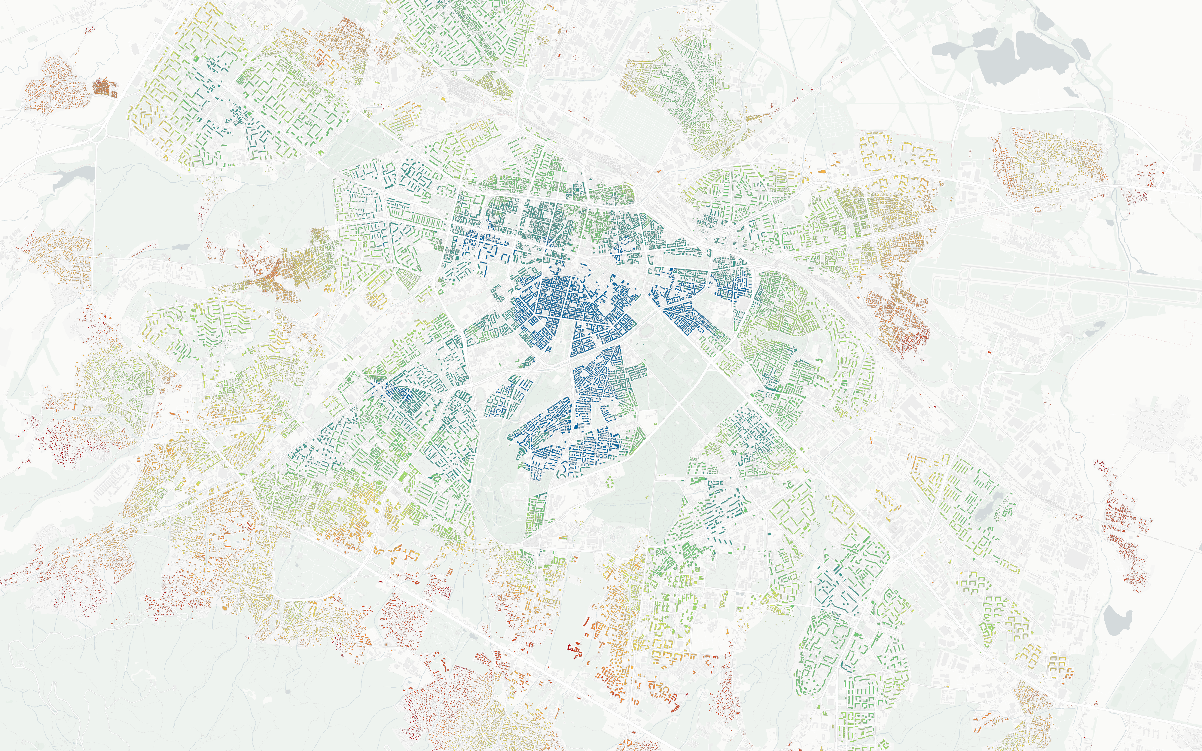
The study explores surrounding of the metro stations within the 0.8 km buffer zones, where there has been an increase in building density and total gross floor area (GFA). This transformation has led to a significant rise in energy consumption, particularly in densely built-up areas.

The parametric urban planning naturally follows the basic idea of the digital twin – "design, test and build first digitally". A tool that provides data-driven decision support on urban planning is developed based on preliminary defined neighbourhood indicators related to population density, access to social infrastructure, transport connectivity, etc.
The social amenities allocation is a challenge in urban planning, requiring an optimal distribution of their locations to accommodate demand while ensuring accessibility. The proposed novel approach tackles it using Constraint Programming, utilising MiniZinc language to formulate the problem, and the Gecode and Chuffed solvers to identify feasible allocations.
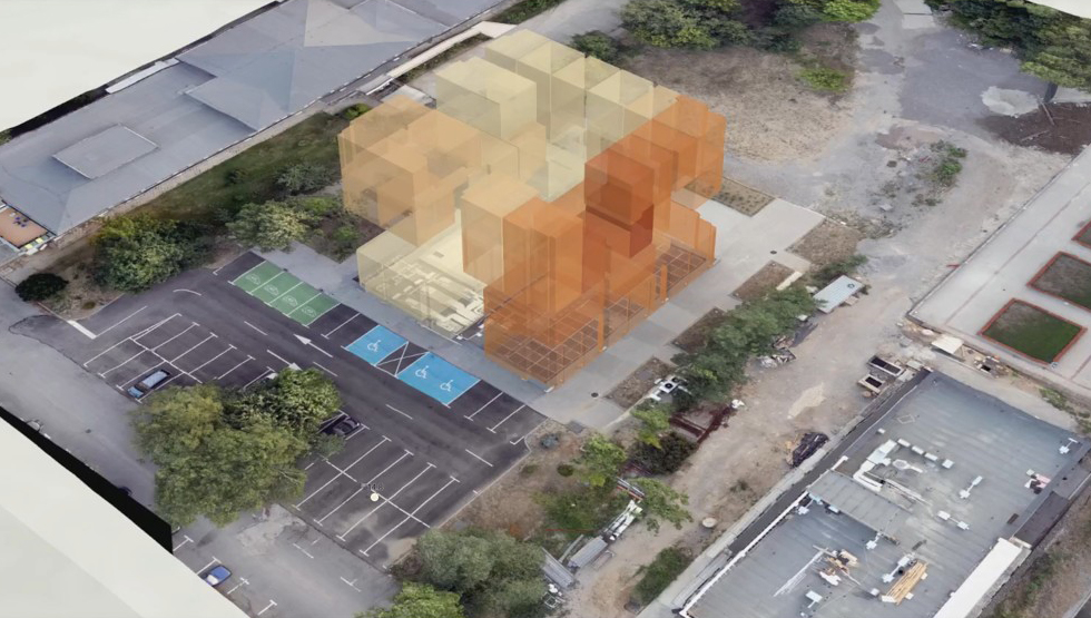
The study showcases the integration of real-time environmental sensor data into a 3D digital twin of the GATE Institute’s building using ArcGIS Scene Viewer. It is focused on temperature modelling and visualisation, a key factor for comfort and energy efficiency.
The 3D city model of District Lozenets and its visualisation are the first steps towards implementation of City Digital Twin pilot project of GATE Institute. It covers the Buildings and Relief thematic modules of CityGML 2.0. The 3D model of the buildings is hosted on the Cesium ion platform and visualized using CesiumJS
The parametric urban planning naturally follows the basic idea of the digital twin – "design, test and build first digitally". A tool that provides data-driven decision support on urban planning is developed based on preliminary defined neighbourhood indicators related to population density, access to social infrastructure, transport connectivity, etc.

An automated approach for assessment of social facility coverage is developed. It solves a supply and demand problem based on a graph network, where kindergartens and nurseries are considered as supply nodes, and residential buildings as demand nodes. Supply and demand are balanced based on a 15-min walking distance and the capacity of social facilities.

Computational Fluid Dynamics (CFD) simulations are now being widely used for the prediction and assessment of high-rise building aerodynamics and pedestrian wind comfort. Results from CFD wind simulation are reliable sources of quantitative and qualitative data useful to make important design decisions.

The aim is to provide a way of combining data from different sensor stations and to develop a platform for the real-time prediction of air quality throughout Sofia city. To achieve this, methods from the field of uncertainty quantification and statistical learning are used, which enable the analysis of existing sensor data in a probabilistic way.
Indoor air quality and thermal comfort are two factors that affect occupant’s health, performance, and overall well-being. They are modelled, analyzed and predicted by applying CFD, so that suitable control measures can be taken in due time. The overall building design, ventilation and heating effectiveness is assessed and optimized through different what-if scenarios.

The study aims to numerically estimate the impact of UHI in Sofia and its surroundings on the air temperature using the state-of-the-art Weather Research and Forecasting (WRF) with very high resolution. The study also estimates the impact of building and transport separately..
Walking is the most accessible form of mobility, delivering benefits to both cities and their residents. To increase walkability, the pedestrian network, integrating all transportation modes, should be optimized. The pedestrian accessibility to public transport stops and parks in Sofia is evaluated by applying network and spatial analysis based on a 10-min walking distance.
The study focuses on developing a novel digital-twin-based approach for micro-traffic simulation to support data-driven decision-making for increasing traffic safety through scenario planning. Leveraging the traffic data obtained through monitoring one of the busiest intersections in Sofia city, this research workflow shows the effective integration of LiDAR data and the urban digital twin concept in intelligent transportation systems (ITS).
This study examines the calculation of solar incident radiation at the city scale in Sofia using remote sensing data for the large shading context in a mountainous region and 3D vector building data. The building footprints and the terrain are preprocessed using GIS. The solar calculation is con-ducted using a raytracing algorithm in 3D CAD at the city scale.
The study calculates the energy consumption of the residential buildings in Sofia based on the “Building certificates of energy characteristics” dataset, provided by the Agency for Sustainable Energy Development. For each building category, a distribution-free tolerance interval is computed ...
The City Living Lab is equipted with 12 air quality monitoring stations, 60 noise measurement stations, 50 pedestrian counting radars.
The Light Detection And Ranging (LiDAR) system for vehicle counting and traffic analysis is realised as an edge computing system at one of the busiest intersections in Lozenets.
Hybrid sensor solution with LRF, zoom, wide and thermal camera.
Integratation of big geospatial data, spatial analysis, and AI methods to understand natural and social phenomena in urban environment.
Applying Computational Fluid Dynamics in indoor and outdoor simulation of air pollution, wind flow and noise simulation.
Visualisation of 3D city models and viasual representation of analytical and CFD results.
Integration of data from a variety of sources, feature extraction and semanticaly enrichment.


Sofia, Bulgaria
5 James Bourchier Blvd., Sofia 1164, Bulgaria
dessislava.petrova@gate-ai.eu